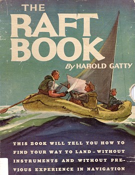
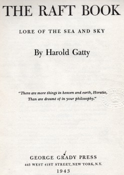
Published in a pictorial slipcase, with 20" x
45" large folded page with 8 charts of latitudes and
adjustments on one side, a world navigation chart on
the other, plus a star chart of same dimensions, and
folding Greenwich date and hour scales. This guide to
navigation without instruments, and without previous
experience, based on Polynesian navigation techniques,
was given to American pilots during WW II.
Harold Gatty
was born on 5 January 1903 in Campbell Town, Tasmania
and began his career as a navigator in 1917, at age 14, when
he was appointed a midshipman at the Royal Australian
Naval Collegeat Jervis Bay, NSW, initially HMAS Franklin and later HMAS Creswell.
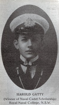
Right: Harold Gatty, Naval Cadet, Royal
Naval College, Jervis Bay, NSW, c1918.
- Brown: Gatty-
Prince of Navigators (1997) page 12.
In 1931,
Gatty
accompanied Wiley
Post on an attempt on world record for
circumnavigating the earth, previously held by the Graf Zeppelin airship in 21 days.
Leaving New York's Roosevelt Field on 23 June 1931 they
completed the fight in 8 days, 15 hours, and 51
minutes.
Post and Gatty were honoured with a ticker-tape parade in New York
City, and documented
their fight in Around the world in eight
days- the
Flight of the Winnie Maein 1931.
While the flight was closer to nine days, rather than eight, the title
referencing Julves Verne's 1873 work of
science fiction, Around
the World in Eighty Days.
Introduction Lore of the Sea and
Sky. Migratory Birds As
Winged Pilots Migration of Insects Land Sighting Birds
As Navigating Instruments Land Indications from
Sea Birds Fish and Other
Surface Life The Scent of Land Sounds from Land The Sky As an
Indicator of Land Directions from the
Wind Directions from the
Wave and Swells
Ocean Currents and the Color of the Sea The Use of
Visual Indications
Winds, Ocean Currents and Temperatures
Estimation of
Distance Use of the Base
Chart Use of the Compass Measurement of
Angles How the Polynesians
Used the Stars How to Recognize
the Stars Directions from the
Stars and Moon Steering by the
Stars Directions from the
Sun How Far You Are
North or South How Far You Are
East or West Ocean Rainfall
Charts Making the Landing
Distribution of Sea Birds, Breeding Places and
Dates
PLATES Explanatory Diagram for Frontispiece Frontispiece—Overhead Stars in the
Southwest Pacific 1-5. Illustrations of Sea Birds for
Identification 6. a. Color Reflected from Cloud
Indicating Lagoon Beyond the Horizon b. Fixed Clouds
Indicating Land Beyond the Horizon 7. Curvature and Meeting of Swells Around
an Island 8-19. Winds, Ocean Currents and
Temperatures of the Oceans 20. Stars of the North Polar Area 21. Stars of the South Polar Area 22-24. Star Diagrams 25. Paths of Stars at Different Latitudes 26. Moon and Sun Diagrams
PAGE vi. vii. 25-35. facing 50.
facing 50. 58. 70-81. 101. 102. 103-105. facing 108. facing 111.
Pages vi and vii[Frontispiece]
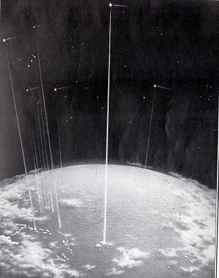
The Polynesians viewed the stars as moving bands of light
passing over the same islands night after night.
They knew the stars which passed over particular islands,
and used these stars as heavenly beacons to lead them to
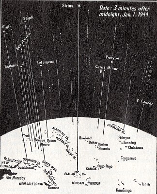
their destination. The frontispiece showing stars
over the southwest Pacific illustrates a specific instance
of the use of Sirius as an overhead star for Vanua Levu of
the Fiji Islands.
The stars are in their actual positions for 3 minutes after
midnight local time on January 1st 1944 (about 4 minutes
earlier on each succeeding night). The above diagram gives the
names of the islands in the frontispiece, and the names of
the easily recognizable stars which are overhead at the
same time in these islands.
The sun sags down on on Tama's path, across the changing
sky; New stars do leap above the deep to meet the
wondering eye; New seas are spread on every side, new skies
are overhead; New lands await the sea-kings, in the vast grey
seas ahead.
Maori song. (After Best)
Page 1
INTRODUCTION
This book has been written for those who, without previous
experience in navigation and without navigating
instruments, find themselves in small craft in the open sea
and who have to make their way to land. The methods contained in this
book include the simple and effective means that enabled
primitive peoples to travel across the oceans, as well as
other ways that have been devised at the present time to fit
your particular problem. It has been definitely
established that primitive peoples had no more "sense of
direction" than we have.
Realizing this, and following their time-tested methods,
you can have full confidence that you
can find your way as well as, or
better than, they could. Many others before you have made
long and successful voyages in very small boats and rafts.
Just because the methods of the Polynesians are frequently
mentioned throughout this book, it should not be thought
that these methods apply only to the Pacific Ocean.
These great seafarers happened to populate the Pacific, but
they could have navigated equally as well by the same means
in the Atlantic. Several new applications of old
ideas have been worked out and are included here
The use of a watch with the simple methods given in the book
will enable you to fix your position in an east and west
direction (longitude).
There are also a number of methods in this book for
obtaining your position in a north and south direction
(latitude). However, it is of the utmost
importance that you carry a watch kept running on Greenwich
Time.
All persons who are sailing the
Page 2
seas or flying over the seas in these times, should
have their watches set on Greenwich Time for their own
safety. With reasonable rations, even
though you are far at sea, you should have no worry about
reaching land.
There are simple ways described in this book to fit all
circumstances. Following are important
suggestions which should be closely adhered to: 1.
If you know where you are when
you board your craft, mark the position and the time on your
Base Chart accompanying the book. 2.
Keep track of your course and
speed as best you can. 3.
Keep as regular a course as
possible without unduly exerting yourself until you are sure
of the direction of land.
You have every chance of being
picked up if you just keep your head and conserve your
strength.
4.
Knowing your position and the
direction to the nearest land does not mean that your best
way is necessarily a direct course.
Let the winds and currents
help you. The longest way round is sometimes the shortest
way home.
5.
Do not let the direction of the
wind at the moment be the basis of your decision.
Study the wind, current and
water temperature charts on pages 70-81 and from the
resultant winds and currents make your decision as to the
most advantageous course to follow.
This book is given with the idea
that it should be read, if possible, before any emergency
arises.
It is hoped, however, that the information and suggestions
it contains will justify carrying it at all times for
repeated reference in helping you to find your way to land.
Page 3
LORE OF THE SEA AND SKY
Present
day navigators are apt to place so much reliance on
mechanical and tabular aids that we sometimes forget that
primitive peoples were able to voyage over a large part of
the world without any such devices.
A study of these primitive methods shows that there are many
valuable aids we have neglected or forgotten, and that a
continued reliance on mechanical aids places us in a very
helpless position when deprived of them.
In the lore of the sea and the sky one can still find those
fundamental and simple means which gave early man confidence
and enabled him to find his way on the trackless sea.
The earliest navigators of history—the Phoenicians, the
Arabians, the Vikings and the Polynesians—all used very
much the same basic methods but applied them differently. In addition to the basic methods
common to all the early navigators, the Polynesians had
many unique and superior means; for this reason much of the
material here presented deals with the art as practised by
them.
Having originally migrated from the west coast of
India, the Polynesians peopled islands over the length and
breadth of the Pacific.
Unlike continental races whose migratory urges never took
them far from shores, the Polynesians were an oceanic people
and were forced to develop the art of direction finding at
sea to a high state of perfection.
Under the compulsion of economic pressure, tribal
differences, or trade in semi-precious greenstone, the
Polynesians made extensive sea voyages throughout this vast
area and maintained frequent intercourse between groups of
islands thousands of miles apart. When one realizes that all of
the habitable islands scattered over the Pacific Ocean in a
triangular area of approximately 4,000 miles
Page 4 on each side extending from the
Hawaiian Islands to Easter Island (2,000 miles off the coast
of Chile) and to New Zealand, roughly constituting what is
now known as Polynesia, were settled by one people, of one
culture and one language, it should be conclusive evidence
that the Polynesians were without doubt the greatest
pathfinders in history.
The back and forth voyages between Tahiti and New Zealand
over a distance of 2,500 miles are a matter of history, as
are also the voyages between Tahiti and Hawaii over a
similar distance.
The last of these voyages was made about the year 1350 A.D.
when a considerable fleet from Tahiti permanently colonized
New Zealand.
The last of the colonizing voyages to Hawaii had ended about
a century previously.
There is very little, if any,
difference between the problems con¬fronting a Polynesian
voyager in the open ocean far from land and those of the
occupant of a raft or life-boat; each must rely on his
ability to determine his position and the course to the
nearest land without the aid of modern navigating
instruments.
You are in a much better
position to solve the problem than the Polynesians were,
because you are equipped in this book with additional simple
and practical ways and means of locating and guiding
yourself ashore.
Any system of navigation is a
combination of a number of methods, each of which must be
used at the appropriate time.
This is just as true today as it was a thousand years ago.
The direction finding methods of the Polynesians have not
been easy to reconstruct; for aside from the fact that they
had no written language, they kept their system of
navigation as a very jealously guarded secret in the hands
of the Tohungas, or priests. This placed the men who knew
their way about the ocean among the most powerful members of
the tribe, since it gave prestige second only to the chief,
and entailed considerable material advantages.
In order to learn their
methods, it has been necessary to look carefully into their
legends and the accounts of early white ex-
Page 5
plorers in the area, and gradually piece together the
essentials of their system.
Because students of primitive culture are not usually
navigators, a complete understanding and interpretation of
the Polynesian system of navigation has not previously
appeared.
Having spent the greater part
of my life in the South Pacific, with the opportunity of
extensive research in primitive navigation, I am satisfied
that solely by use of these same methods anyone in any ocean
can find his way to land. The Micronesians, inhabiting
the many small atolls of the Caroline and Marshall groups,
to the northwest of the Polynesian area, are people of a
distinctly separate wave of migration and are of part
Mongoloid origin.
Most of their methods for
finding position on the high seas are identical with those
of the Polynesians, but in addition they evolved a system of
charts particularly suited to the conditions throughout
their scattered groups.
As with the Polynesians, their means of find¬ing their way
was kept a closely guarded secret. It was not a monopoly of
the chiefs' families, but more the secret of certain
intelligent individuals who, with marked powers of
observation, were especially trained in this art, and, in
turn, transmitted it to similarly gifted members of their
families.
Like the Polynesians, the Marshall and Caroline Island
navigators enjoyed special privileges usually reserved for
the chiefs.
They were permitted to walk on the weather side of an
island, and they possessed very high social standing
to¬gether with the advantage of the use of more land.
It is interesting to note that
a century after the last of the great Polynesian colonizing
migrations, we read of the pre-Columbian navigators of
Europe still being afraid to venture out beyond the Pillars
of Hercules into the Green Sea of Darkness, the Atlantic. Page 6
MIGRATORY
BIRDS AS WINGED PILOTS
Birds have played a far greater part in the opening up of
the world than is generally realized.
It is the writer's conviction that man has been led across
the water to other lands by migratory birds.
A study of the tracks of the migration of land birds in the
Pacific, and further consideration of the evolution of bird
migration routes, shows that man's path in the Pacific has
followed the paths of land birds.
No people, whether primitive or civilized, would set out
over thousands of miles of ocean without knowing that they
were going to some land.
The Polynesians, who were, like all primitives, close
observers of nature, saw the land birds taking off year
after year in the same direction, and knowing that they were
not able to rest on the ocean, must certainly have realized
that another land lay in that direction.
What else would lead these seafaring people from Tahiti to
New Zealand but the repeatedly observed migration of the
Long-tailed Cuckoo between these two places?
In such migration flights, the
Long-tailed Cuckoos do not all set out at once, but straggle
over a period of two to three weeks, the young ones taking
off first and the older ones later; and, since their flight
level is never very high some part of the migratory flock
can always be seen by day or heard by night.
The Polynesians setting out to
follow such a migration route took a careful departure by
lining up range marks on the shore previously determined
from the flight of the birds.
Having once made the voyage and observed the many other
indications along the route, they eventually needed the
birds no longer and voyaged back and forth with perfect
confidence.
This same condition applied between Tahiti and Hawaii, along
one of the tracks of the Golden Plover which migrates
between Alaska and Tahiti.
As Wells Cooke, of the U. S. Biological Survey, has
suggested in "The Book of Birds" by Henry Henshaw, there has
been an evolution of the migration routes of birds in the
Pacific
Page 7
as there has been on the American continent, where the
Golden Plover has, over a period of centuries, shortened its
tracks.
This latter far flying bird, many centuries ago, may have
taken a path from the northeastern tip of Siberia down the
Asiatic coast through the East Indies and a little south of
the Equator to Tahiti and the Marquesas; along the very path
from the East Indies across the Pacific as followed by the
first Polynesian stream to these groups.
At a later period, the route of bird migration from
Siberia is thought to have been from the Kamchatka Peninsula
through the Japanese Islands and by way of the Caroline and
Marshall Islands to Tahiti. The second Polynesian route was
through these Micronesian Islands.
A later, and in fact, one of the several present day routes
of the Golden Plover is from Alaska through Hawaii to
Tahiti.
It is believed that the Hawaiians were led to their islands
from Tahiti by these same birds.
In a like way, I believe that the original inhab¬itants of
New Zealand, who were Polynesians with mixed Melanesian
traits, came to New Zealand from Polynesian settlements in
the vicinity of the Solomon Islands, following the migratory
track of the Shining Cuckoo.
I have dwelt on this to stress
the fact that the flight of birds was very closely watched
by these oceanic people.
Like all primitive wanderers, they realized the great value
of noting the flight of birds as a means of finding
direction.
MIGRATION OF
INSECTS
Butterflies or other insects are sometimes seen hundreds of
miles out at sea; hence, they should not always be taken as
an indication of being close to shore. It has been
established that some of them
Page 8 migrate very long distances over water.
Moreover, the direction of their flight is apparently little
influenced by the prevailing winds since they have been
observed in enormous numbers flying against the wind just as
often as with it.
During migratory flights,
butterflies rarely fly as high as 100 feet and hence are
always easily seen.
Unlike migrating land birds, whose direction of flight is
always from one point of land to an¬other, only the
direction from which the butterfly has come is of any value
in determining the direction of land.
Butterflies are known to cover several thousands of miles in
their migrations.
It is definitely known that they do not migrate for food,
for their mass flights take them into many unfavorable
places such as out to sea, across the ocean or towards the
Arctic regions where they perish.
As an aid in pointing towards land, the only clue to be
drawn from the migration of butterflies when seen at sea is
that they have come from land.
Although the direction from
which migrating insects are coming points towards land, any
one such indication alone is rarely entirely reliable of
itself, but should be correlated with all other observations
denoting land.
It has been recorded that a single stable fly alighted on a
small vessel which was still fifty miles off the southeast
coast of the United States.
This would not of itself be positive evidence of the
proximity of land; yet, correlated with other equally
suggestive findings, it would strengthen the probability of
land nearby.
LAND SIGHTING
BIRDS AS NAVIGATING INSTRUMENTS
Shore sighting birds, carried by
all primitives, when released, made their way to the nearest
land.
This was a method common to the
Page 9
Phoenicians, the Arabian navigators of the Indian Ocean, the
Vikings in the Atlantic, and the Polynesians and
Micronesians in the Pacific.
The story of the deluge in Babylonian and Hebrew literature
describes the well-established use of shore sighting birds.
When Floki, the Norse navigator, left the Shetlands for
Iceland, he carried a number of Sea-Ravens (probably Shags).
A few days out, one of these birds was released.
It circled for altitude and seeing land astern flew towards
it, thus giving Floki a back bearing on his point of
departure.
Several days later, a second bird being released returned to
the vessel after circling and seeing no land.
Eventually one of the birds, upon being released, took a
forward course to Iceland which indicated the final
direction to their destination.
The Frigate (or Man-of-War) Bird
was the shore sighting bird of the Polynesians and being
plentiful in these regions, was always available.
Although an oceanic bird, it does not normally land on or
take off from water.
Even in recent times, Frigate Birds have been used as
message carrying birds between the islands.
On Ocean and Nauru Islands in
the central Pacific, Frigate Birds are still kept as pets
but probably because the native voyages have ceased, the
islanders have forgotten the origin of the custom.
The most adaptable bird for
shore sighting would appear to be the trained pigeon, and
there seems no reason why such birds could not be carried in
lifeboats and in rafts.
Upon being released a pigeon would circle for altitude and
either go to land, or, if no land were in sight, would
return, and enter its cage again.
If two birds were carried, the
first bird could be released, and after noting the direction
which it took to the nearest land, the second bird could be
dispatched with a message giving the bearing.
If carried, these "feathered instruments" would at least be
available for food if not used as messengers.
Even the corn with which to feed them need not be wasted.
Page 10
LAND INDICATIONS
FROM SEA BIRDS
He who, from
zone to zone, Guides through the
boundless sky thy certain flight, In the long way that I must tread alone, Will lead my steps aright.
To a Waterfowl—BRYANT
One of the most important ways
of telling when you are near land and in what direction it
lies, is by carefully noting the flight of sea birds.
There is nothing very difficult about this if the main bird
types can be recognized.
Each area of the ocean has its
own characteristic temperature, depth, salinity and
movement, and thus its own particular marine life. It is
this marine life which determines the type of bird found
there, and, hence, by identifying the birds that you see you
will know many things about the area in which you find
yourself.
Robert Cushman Murphy, in his
authoritative work, "Oceanic Birds of South America,"
states: "... if the quality of the
water may tell us something about the birds, the birds
should also tell us much about the water.
The Snow Petrel requires water which is cool; Tropic Birds
prefer water which is clear, dense, saline and moderately
warm; the Brown Booby clings to water inhabited by flying
fish which, in turn, are limited to water of definite
temperature and gaseous content."
He goes on to say that in the
Tropical Zone the relative scarcity of oceanic bird life
contrasted with conditions in cooler latitudes, is very
striking.
In general, the majority of tropical sea birds do not range
far from their breeding grounds on islands, island groups
and continental coast lines.
The presence of man, animals or other natural enemies on the
larger islands reduces the bird population, but on the small
islands in the Tropical Pacific and Indian Ocean, where the
birds are not disturbed, they breed in large numbers.
One observer making a long
cruise in the Tropical Pacific re¬corded an average of only
one bird for every 125 miles of open sea. In fact, one may
travel for days across tropical oceans and see no
Page 11
birds at all.
If you are in such an area, do not let this discourage you
for there are many other ways of locating yourself that you
can use. It will be realized then that the value lies in
watching for the increase of birds and the presence of
certain birds as an indication of approach to land. Another observer on a voyage
between San Francisco and Tahiti noted that for the first
two days North American coastal birds were seen, after which
for five or six days he saw only an occasional petrel.
Nearing the Equator, when scattered woolly clouds became
thicker and grayer, the swell increased, rainstorms came and
suddenly numerous birds appeared.
Among these were Storm Petrels and Red or White-tailed
Tropic Birds; then, as islands were approached, large
numbers of Terns were seen.
As the ship proceeded farther along the birds dropped away
as abruptly as they had first appeared. This sudden appearance and
disappearance of bird life in the Doldrums or when passing
from one current or ocean area into another shows what
different conditions may be found in neighboring waters.
One locality may be rich in its ability to support bird
life, which conditions may be entirely lacking in another
area nearby.
Such change in bird life is strikingly seen at the meeting
of one current with another where an upwelling of the cooler
water from the depths brings food to the surface.
An example of this is where the Gulf Stream meeting the
Arctic Current causes extensive eddies and contrasts. Far from land, especially in
the tropical regions, sea birds are very scarce, and this is
where you may need them most for food. All sea birds are
edible and are not difficult to catch provided you have a
fishing line and can float a baited hook.
The Albatross and other hook billed birds may be caught with
a shiny metal object that will catch in their bill.
Other birds will dive and gulp any hook baited with a bright
rag or suitable object. The flesh of sea birds and fish
may glow in the dark but is still good to eat.
Page 12
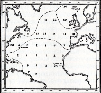
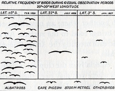
The top [left] chart
of the North Atlantic shows the average number of birds seen
per day. We note that 100 birds were
observed daily around the Faroe Islands, only 1 per day in
the middle of the Atlantic, 4 in the vicinity of Bermuda and
34 around the Cape Verde Islands.
- After Jespersen
- From Murphy after
Spiess
It is interesting to note that on
a line between Bermuda and the south of Spain, 1 bird per
day was seen in the middle of the Atlantic, increasing to 4,
7, and 15 as Gibraltar was approached. The lower [right] diagram for the South Atlantic
shows that an increasing number of birds appears as one goes
south of the Equator.
Page 13
HABITS OF SEA
BIRDS
The habits of a representative
number of sea birds are given as a general indication of
their value in determining the vicinity or direction of
land. From pages 24 to 33, plates and
accompanying descriptions of 43 species of sea birds will be
found. The illustrations by the
eminent bird artist, Francis L. Jaques, are drawn so that
the distinctive features of each species may be easily
recognized. After recognizing a bird from
the plates and description, a glance at the tabled summary,
"Land Indications from Sea
Birds" following the identification plates, will show what
may be deduced from observations of a particular bird. Reference should be made to the
distribution, breeding places, and dates of breed¬ing at the
back of the book, pages 141 to 152, for a more certain
indication.
It will be noted that at different times of the year,
according to whether birds are breeding or not, their
habits, and therefore their importance as indicators of
land, will vary accordingly. The tabled summary is given as a
general guide. It should be borne in mind that
there will be exceptions, and that the art of finding land
is made up of many evidences, which when put together,
result in more certain assurance of the distance and
direction of land. General information on the
habits of the families comprising the 43 representative
species, which is intended to augment the tabled summary,
follows.
ALBATROSSES See plate 1 and
pages 24,141,142 for further data.
The albatross sleeps on the
water, and like a number of other oceanic birds drinks salt
water, thus never having need to seek land except in the
breeding season. It is not difficult to catch. One method which I have used
successfully off the south of New Zealand is to trail a
small open triangle of brass on the end of a line. The albatross, attracted by the
shining
Page 14
metal, gets his curved bill
caught in the triangle. It is then an easy-matter to haul
him gently aboard, after which he becomes violently seasick.
If you do catch one, watch your hands because this bird has
a very sharp bill.
The strong, hooked bill is common to all albatrosses.
There are thirteen known
species of the albatross family.
Nine of these are found in the southern oceans, three in the
Northern Pacific, and one which breeds in the Galapagos
Islands off the northwest coast of South America. Although the greater number of
Southern Hemisphere albatrosses breed from December to
February, it is believed that they breed only every second
year.
For this reason, they may be found far out at sea at any
time of the year and are, therefore, at no time a sure
indication of land. When the North Pacific
albatrosses are not breeding, that is, from April to
October, it is quite possible that any small number may be a
long way from land.
PETRELS See plates 1, 5, and pages
24,32,142,143,148,149, and 150 for further data.
The family which includes the petrels, shearwaters, fulmars,
and the Cape Pigeon spend their time at sea when not
breeding. The majority of them stay close to their breeding
grounds, but others migrate from one hemisphere to the
other.
Even when at sea, they like to congregate.
They are surface feeders and may be seen very often skimming
the water, and some of them dive for food.
In order to derive any value from the observations of birds
of this species as indications of land, it will be
necessary, after identifying them, to refer to their
distribution, the location of their breeding places, and
dates of breeding. It will be noted that the
fulmars are found only in the Northern Hemisphere and are
truly oceanic birds.
They are one of the most numerous birds of the northern
oceans.
The Cape Pigeons, also oceanic birds, are found only in the
southern oceans.
These noted ship followers may be seen far from land.
They will be found in far Pages 15 to 23
Petrels, continued.
Booby Birds and Gannets, Tropic Birds,Frigate Birds, Cormorants (or
Shags) and Pelicans, Penguins, Skuas and Jaegers, Sea Gulls, Terns and Noddies, Phalarope, Puffins and
Murries, Guillmots and Auklets.
Pages 24-34 Plates and descriptions of birds.
Pages 35-38
Land Indications
from Sea Birds [Tables]
Page 39
FISH AND OTHER
SURFACE LIFE
Suface life is an indication of
the character of the sea water and may thus help you
recognize some well known current or area of the ocean such
as the Gulf Stream, Humboldt Current, Equatorial or
Counter-Equatorial Current; for in passing from one region
to another there are very noticeable and characteristic
changes in the marine and bird life.
In the open ocean far from shore one does not find the rich
life frequently thought typical of these deep waters.
The marine forms enountered are apt to be limited to whales,
porpoises and the few particular types of ocean-ranging fish
described below.
Rather than attempt to describe
the countless different forms of coastal fish, we list below
only those fish found far at sea, and which are few in
number.
These deep sea fish are given so that they may be eliminated
as indications of nearness to land.
Any other forms are likely to be coastal varieties.
Deep sea fish may at times be
seen close to the shore, but the coastal fish, especially in
any numbers, will not be found far at sea.
BLUE SHARK
[Each species entry includes a
black and white illustration]
This slender frequenter of the warm seas is the only
shark usually found far out from land.
Most other sharks stay close to shore.
The Blue Shark, found in tropical waters throughout the
world, is of a deep to bright blue color.
The average adult is about 12 feet in length but some reach
as much as 20 feet.
[Illustration]
Most sharks are accompanied by pilot fish swimming
freely alongside of them wherever they go.
The pilot fish which accompany the Blue Shark, however,
differ from the pilot fish found with the coastal sharks.
The Blue Shark's pilots are as round as cigars and
Page 40
have black cross bands, while the coastal sharks' pilot fish
are flat.
The Blue Shark is excellent eating and not difficult to
catch, provided you have heavy enough tackle.
Some sharks have a great deal of ammonia in the flesh and
are inedible unless the ammonia is removed by washing or
drying out.
If the flesh is sliced into small pieces, towed astern for a
few hours and then dried out, it should be edible.
A simple method of catching sharks still used by Samoans is
to hold some bait in the water near the bow of the canoe
while a large noose is held over the side amidships.
The shark, attracted by the bait, comes alongside and swims
through the noose towards the bait.
A sudden tightening of the noose around its middle is
followed by a quick heave on the line by several natives.
In this manner the shark is hauled bodily into the canoe and
is quickly clubbed to avoid upsetting the craft.
Trailing the foot as shark bait is not recommended, but,
with other bait lacking, it has proved successful. It will
be realized, of course, that there are limitations to what
can be tried in a rubber boat or life raft.
Handling a fish that may be up to 12 feet in length requires
common sense as well as a stout line.
If you can catch the shark, you can catch the pilot fish.
You may also find Remora fishes which attach themselves by a
sucking disc on the top of their heads to the under surface
of the shark's throat.
Remoras reach a length of 1 to 2 feet.
If luck comes your way and you catch a Remora you can put it
to good use by keeping it alive.
Taking care to keep your hands away from its razor-like
gills, tie a line securely onto its tail.
Now turn the Remora loose and give him as much line as you
can spare.
He will fish for you and attach himself to any shark or
turtle or large fish that comes in his range.
After he is stuck on, haul them both in.
Repeat this until you or the Remora gets tired.
This is not a "fish story" but is common practice among
native fishermen in the tropics.
Page 41
BLUE WATER PORPOISE
There is only one really deep sea porpoise and it is found
in the warm waters of all oceans.
It is somewhat smaller than most of the coastal types and
has an irregularly shaded grayish body averaging about five
or six feet in length.
Usually seen in large schools, it can be readily identified
by its habit of jumping clear out of the water.
All other kinds of porpoises are usually coastal.
The porpoise is edible but difficult to catch except by
harpooning.
The shoulders provide the best steaks.
SUN FISH
...
OCEAN BONITO
...
Page 42
...
DOLPHINS
These fish, found in all the warm blue oceans,
travel in schools and are the greatest enemy of the flying
fish.
Having somewhat flattened sides, their bodies are elongated,
tapering gradually from shoulder to tail.
They reach a length of 6 feet but a fair average would be 3
or 4 feet.
Dolphins are oceanic fish and in no wise indicate nearness
to land.
The Dolphin is probably the fastest swimming fish in the
ocean.
In vivid blues and yellows it is one of the most brilliantly
colored of all fish.
It can be caught from any moving craft on a hook set in a
piece of wood with a white rag attached.
If the lure is barely allowed to touch the water and jerked
into the air and made to imitate the action of a flying
fish, the Dolphin will usually strike.
Around any logs, cases, barrels and other drift found in the
open ocean, young Dolphins 4 to 12 inches long will usually
be found.
They can be caught with a baited hook.
Page 43
FLYING FISH
Although very welcome as food, Flying Fish are of no value
as a sign of land for there are about 20 to 30 species, some
of which are coastal and some only met with on the high
seas.
They are quite easily caught at night by holding a light,
mirror, or any available glittering object in front of a
shirt, sail or other obstruction.
Pages 43-45
Sargassum Fish, Ocean Pipe Fish, Latern Fish, Black Rudder
fish, Trigger Fish (Leather Jackets), Sea Snakes, Common
Floating Forms. Page 46 The Portuguese Man-of-War is
also of the jellyfish family.
It appears as a crested, delicately pink and blue
bladder-like form four to eight inches long floating on the
surface and trailing long jelly-like threads
A very painful sting will result from handling them.
They may be seen in considerable numbers a long way out to
sea.
SEAWEED
A well known indication of land is seaweed, for it is
usually a shallow water vegetation.
On being detached it may be carried for some distance off
shore by wind, currents, or tides.
Thus, consideration should be given to the direction in
which this plant life may have drifted away from its origin.
It will be recalled that Columbus observed seaweed and other
floating debris as he approached the West Indies.
In one particular region of the
North Atlantic, the appearance of seaweed does not
necessarily indicate nearness to land.
This is the Sargasso Sea, an area of relatively stationary
water 1,000 miles in diameter extending from 200 to 400
North and from 400 to 700 West.
Here, encircled by the Gulf Stream on the west and north,
and the Northeast Trade Drift on the east and south, are
enormous beds of densely growing sargassum, similar to, but
apparently quite unassociated with the coastal type of such
seaweed.
The attention early seafarers
paid to signs of nearby land is illustrated in the journal
entry of Abel Janszoon Tasman, the famous Dutch navigator,
in 1642:
"Towards evening, we again saw
various lots of rockweed floating about, and observed large
numbers of tunnies [bonito] near and round about the ship;
our boatswain's mate and one of the sailors also saw a seal
from which we surmised that there may be islands hereabouts,
since the said animals are not likely to go out far to sea;
on this account we did not venture to run full sail."
Page 47 In the Temperate and cool
latitudes, any seals and sea lions observed, may, as Tasman
remarked, be relied on as being very close to shore.
THE SCENT OF LAND
The accounts of early voyagers all contain frequent
references to the odor of land still beyond the horizon.
One of them speaks of the odor of rosemary off the coast of
Spain more than ten leagues out at sea.
And one who accompanied Sir Francis Drake in the
Pacific in 1577 writes:
"From hence wee directed our
course towards the South-Southwest... at which time wee had
a very sweet smell from the land ... and wee had sight of
the land about 3 of the clocke in the afternoone the same
day."
Various parts of the world have
their own particular odors.
The smell of burning peat may be picked up many miles out at
sea from the Falkland Islands as can the scent of the orange
groves approaching the Cape Verde Islands, while the
sweetish rancid odor of the drying coconut may be detected
far out at sea in tropical regions.
The penetrating odor of ammonia may betray the sea-bird
roosts on small islands.
The smell of bush or forest fires, factories, oil
refineries, or other odorous industries, all indicate land
not far off, as do the characteristic odors of beach or
tidal lands, or the sweet smell of earth, especially after
heavy rain.
I have personally experienced
the fragrance of new-mown hay 80 miles off the New Zealand
coast in the springtime. The detection of any land odor,
especially in fog, mist, rain, or at night when odors are
usually stronger and are carried out to sea by the land
breezes, is very important, for you may be
drifting past
Page 48
a nearby shore.
The Polynesians on their long voyages frequently carried
pigs with them and watched them closely, since having a
highly developed sense of smell, they became excited on
smelling land still far out of sight. Odors are carried by the wind
and therefore any new odor detected at sea should be
considered a possible indication not only of the vicinity of
land but of its direction.
SOUNDS FROM LAND
Nature provided you with ears that you might hear.
The fact that you have two ears not only enables you to hear
but to tell the direction from whence the sound is coming.
Sound often carries very great distances over water and,
when other aids are lacking, may be very valuable in
locating land.
The distances at which sounds can be heard over water are,
of course, affected by the strength and direction of the
wind. The roar of heavy surf may be
heard long before the shore is seen.
At night, the continued cries of sea-birds from one
particular direction will signify their roosting place on
land.
Among sea-birds, as
distinguished from migrating land birds, the gulls are
practically the only ones that make any noise when in
flight.
As the Kittiwake is the only gull that is found far out at
sea and is restricted to the North Atlantic and the high
latitudes of the northern Pacific, one may be safe in
assuming that outside of these regions the sound of birds at
night generally indicates land, or the direction of land.
It is possible that during fog
or nighttime you may be close to a
populated shore where the sound of trains, marine fog
signals, facctory whistles or other signs of industrial
activity can be heard.
If
Page 49
in fog and you hear a ship's whistle or siren, you may
assume the vessel is moving; but if bells are heard at
regular intervals the sound is either coming from a ship at
anchor or from a bell buoy or other stationary marker.
When close to high rock-bound coasts, especially in fog or
during the night, one may judge the distance off-shore by
firing a pistol or shouting and listening for an echo.
This principle is followed by ships in the inland waterways
of Norway, British Columbia, Labrador and Alaska, where the
ship's whistle is used and the echo timed.
As sound travels at the rate of 1,100 feet per second (5
seconds to the mile), distance offshore can be deduced from
half the difference between the time the sound is emitted
and the time it returns.
By shutting the eyes, it will be found much easier to
concentrate on the direction from whence the sound is
coming.
By turning the head, in order to get equal volume of sound
in each ear, it is possible to obtain a very close
approximation to the bearing of the sound.
By taking into consideration the type of sound and the
velocity and direction of the wind it may be possible to
judge fairly closely the distance of the origin of the
sound.
The cessation of the sound of waves breaking on shore may
indicate the presence of an inlet or harbor.
THE SKY AS AN
INDICATOR OF LAND
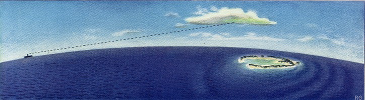
Clouds were closely watched by the Polynesian navigators and
were used in many ways.
The white sands of the coral atoll reflect more heat than
does the surface of the surrounding water, causing a
difference in the temperatures above these surfaces, which
results in a small cloud hovering over the atoll.
It will not be directly overhead but a bit on the lee side
due to
Page 50
the effect of the prevailing wind.
The bright turquoise lagoon is reflected from the underside
of the hovering cloud and can be ob served by the navigator
miles before these low-lying atolls appeal above the
horizon.
Even in the absence of any clouds, lagoons or other shallow
waters will cause a reflection in the sky itself that is
very conspicuous.
Because light is lost in the depths, deep waters are poor
reflectors and produce little if any such effect in the sky.
Matthew Fontaine Maury, the renowned American oceanographer,
in his "Sailing Directions," speaks of hovering clouds being
observed not only over coral islands but over shoals.
"They are often seen to overhang the lowest islet of the
tropics, and even to stand above coral patches and hidden
reefs, 'a cloud by day/ to serve as a beacon to the lonely
mariner out there at sea, and to warn him of shoals and
dangers which no lead nor seaman's eye has ever seen or
sounded out."
The reflections from the ground or water, on the underside
of the clouds can be used in many other parts of the world.
In Polar regions, the reflection from the surface results in
what are known as "water skies" and "ice blinks" and which
respectively indicate the lack or presence of reflecting
surface.
A "water sky" is a sharply defined shadow in an otherwise
bright sky, most clearly defined in low clouds, and
indicates open water in the midst of ice.
Conversely, an "ice blink" is a sharply defined patch of
brightness in an otherwise gray sky and is a sign of areas
of floe or shore ice in the midst of open water.
Polar explorers have always paid considerable attention to
these effects.
These indications in the sky, usually seen as reflections on
clouds, can even be seen in a clear sky.
This is illustrated in a desert region where the reflection
of dazzling white sands is called "desert blink."
The light from cities can be seen at a very great distance
as reflected in the sky, especially by high clouds and can
be used similarly.
Lighthouses may be seen even when far below the visible
horizon, by the light reflected in the sky or by clouds.
Page 51
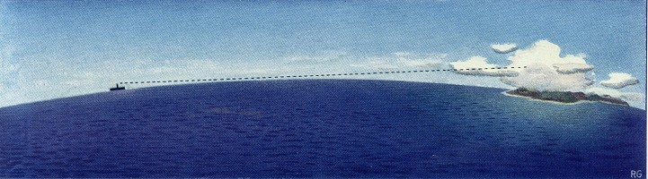
Plate 9
Color of lagoon reflected
from cloud indicating an atoll beyond the horizon.
Fixed clouds
around peaks with moving clouds passing by them,
indicating land beyond the horizon.
Page 52 [blank]
Page 53
There are innumerable examples of the practical value of the
observation of reflections in the sky such as the following:
Henryk Arctowski states:
"On January 19 [1898], Commandant de Gerlache pointed out
die ice-blink in In- South.
The sky was uniformly covered with a thin layer of stratus
[cloud], mill just at the horizon a white line appeared like
a longitudinal slit, detaching Itm If by its brightness from
the grey of the sky.
It was discontinuous, a little iiuilulated, not rising
more than 10 to 25 feet above the horizon.
At 8.00 P.M. Lecointe reported the first iceberg, which
appeared like a dome rising sharply out of the sea at a
distance of about 10 miles."
Lieut. De Haven, during the search for Sir John Franklin,
looked for an open sea to the northward and westward.
He saw, in that direction, a "water sky."
On this information, Captain Penny later successfully
searched in this place for open water and sailed upon it.
FIXED CLOUDS
It is characteristic of high islands or coastal land in many
parts of the world to have fixed clouds or cloud crests
around the summits.
At long distances off, when the peaks are not visible, these
fixed clouds may be seen and
may be recognized by moving
clouds passing by them.
It is important to fix the attention on any stationary cloud
mass and observe the movement of clouds around it.
This means of indicating land has been used not only by all
primitive peoples but by all the early European navigators.
Bougainville and Dampier paid very great attention to this
means, as their log books testify.
La Perouse, one of the early French navigators in the
Pacific, lacking many of the devices of modern navigators,
was a close observer of visual indications of land, and
states in his journal:
"We saw a great number of birds, among which were curlews
and plovers, two species that never fly far from land.
The weather was cloudy, with squalls; but it cleared up
successively in every part of the horizon except the South,
where large clouds
remained constantly fixed which made me believe
that there was land in that quarter." [Italics by author.]
Page 54
The large fixed clouds were an accurate sign of land, but La
Perouse was wrong regarding the curlews and plovers, because
these are of a species seen upwards of 3,000 miles over
ocean water on the migration route from the Aleutians to
Hawaii.
When the land is high there often is a distinctive piling up
of the clouds which, even when there are no moving clouds
passing by them, reveal by their structure the presence of
high land.
These masses of woolly clouds generally offer a contrast to
the trade wind or other clouds which are typical of "over
water" conditions in such areas.
In tropical regions lightning from one particular direction
in the early hours of the morning before sunrise is usually
a sign of land.
This is most often the case when the land is mountainous, or
of con-siderable extent.
DIRECTIONS FROM THE
WIND
On most of the oceans of the world the prevailing winds may
be used as indications of directions.
Although they are by no means constant, it is possible to
tell from the character of the wind, that is, by the
temperature, humidity, force and type of cloud accompanying
it, the direction from which it has come.
If this direction can once be established and used to steer
by, it is not difficult to note a change in direction by
means of a change in any of the aforementioned
characteristics.
For instance, if you are below the Equator, being blown
before a wind which, by its condition, you know to be the
southeast trades, and sometime afterwards experience a
sudden drop in temperature and humidity, you would probably
be correct in assuming that the wind had gone around to the
southwards.
Page 55
Trade clouds in the tropics are usually recognized as small,
isolated woolly tufts outlined against a blue sky, generally
appearing in a uniform layer below 7,000 feet.
Should you see these trade clouds disappear and see the sky
become overcast with heavy, billowing clouds, there is every
likelihood that the wind has gone around through south to
southwest or westerly.
Near continents or islands of any extent, especially in the
tropics or in temperate climates in the summertime, changes
of wind after sunset or during the night might mean a breeze
from the land.
The surface of the sea takes longer to heat than the land
area, but retains its heat much longer.
After sunset the surface of the land becomes cooler while
the air over the sea is warm.
The warm air over the sea rises and the cool air from the
land flows out to take its place.
The direction from which such land breeze is coming reveals
the direction of land.
For this reason you should be on the alert for any possible
scent from land during the night or early morning.
Steering in a direction relative to the wind, if the wind is
reasonably constant, is quite practicable.
This is especially so when you have no compass, and was a
method of steering commonly practised by Arabian, and,
later, by Polynesian navigators.
The Polynesians left the coast of India before the
introduction of the magnetic compass from China by Arab
traders in about the second century A.D.
They were able to direct their courses without its aid, and,
if necessary, you can do
likewise.
A directional system brought into the Pacific by the
Polynesians, but which was borrowed from the Arabs, was the
division of the horizon into 32 points.
This division, which can still be found on our present-day
marine compasses, originated with Arabian navigators before
they had the magnet.
They took the rising points of 15 stars on the eastern
horizon, their setting points on the western horizon, plus
north and south, and used these 32 points in denoting
direction.
Page 56
The Arabians constructed a dial of wood with 32 spikes
spaced around its circumference.
If they knew one direction, as from a well-established
prevailing wind, or star or other sign, they could steer any
other direction relative to it.
In other words, the device was used as a pelorus or dummy
compass.
The "wind calabash" of the Polynesians was evidently a
pelorus to be used in the same way the Arab navigators used
the dial of wood.
The commonly accepted story of the "wind calabash" being
used to measure the height of the Pole Star for the direct
determination of latitude is erroneous.
DIRECTIONS FROM THE
WAVES AND SWELLS
Lacking a compass, or with overcast skies, the direction of
the swell or wave motion is the best nearby means of
maintaining a steady, required direction.
Winds may suddenly change but the direction of swells will
not; they are carried on by their momentum and it takes
prolonged effect of a wind to disturb their path to any
con¬siderable extent. With a change of wind the wave motion
changes first, while the swell persists for a longer period
in its original direc¬tion; thus a peculiar effect of a wave
motion in one direction and a long swell in another is often
seen.
Modern navigators would be at a loss if asked to navigate
with¬out the use of radio or without reference to the sky,
landmarks or soundings for depth. The surface of the sea is
just a lot of water to them.
The ever-changing appearance of the sea was full of meaning
to
Page 57
the Polynesians.
The general form of the waves and the innumer-able other
effects caused by the vicinity of land on this wave motion
were of the utmost value to them as navigating aids.
Careful observation of the sea close to the islands was all
the more necessary because soundings were impossible in the
extreme depths surround-ing their coral islands.
By using their eyes, they learned to interpret the
characteristics of wave formations which in many instances
were as dependable as definite landmarks.
The Micronesians navigated in the same way throughout their
island groups but they evolved a unique method of charting
the surface waters.
Using the ribs of coconut palms and tying them together with
coconut fiber, they constructed a framework to represent the
curvature and meeting points of the wave motion in and
around the islands.
The islands were represented on this framework by small
shells.
The charts were not actually made to scale, for the native
thinks of distance in terms of time, that is, so many canoe
days from one place to another.
They were really aids to memory.
There were three types of stick-charts; simple instruction
charts used in teaching, general charts of a large area, and
charts of local areas.
Although 43 examples of these stick-charts are preserved in
museums throughout the world, charts of the same areas
differ considerably.
The reason for this is that each navigator made one for his
own use and incorporated in it any ideas that were of
particular interest and help to him.
We have much to learn from a consideration of their methods.
The main thing to learn is to see the water, not as a
meaningless mass, but to look for those indications which
were so full of significance and importance to the native
navigator.
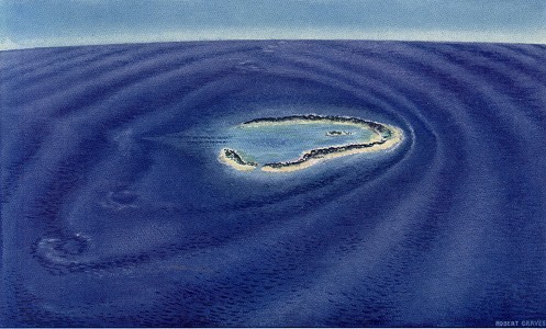
The prevailing wind brings parallel swells towards an
island.
As the swell approaches the island, even out of sight of
land, it starts to curve, and, nearing the island, it curves
to the shape of the obstruction.
At this stage, the swells which are directly in front of the
island start to form into smaller waves which gradually
build up and break
Page 58
on the reefs.
This wave motion from the direction of the prevailing wind
is easy to see.
On the opposite side of the island is a counter-swell much
less noticeable but nonetheless visible to anyone who looks
for it. Knowing of its existence, I have seen this
counter-swell with my own eyes, not only from the water but
from the air where its curves as it approaches the island
are easily recognizable.
At right angles to the direction of the prevailing wind each
counter-swell meets a swell from the opposite direction,
causing a slight eddy or disturbance in the water.
When the Micronesians were steering for an island and missed
it, they would reach this row of meeting points of two
opposing swells and sail down it as a line of direction to
the island.
At nighttime, luminescence indicates the position of these
wave intersections and can be used in a similar manner.
I have outlined merely the simplest case of the use of the
Micronesian study of wave motion, but in addition, they used
the crossings of the swells of one island with those of
another.
In other words, the native navigators charted the
directional characteristics of all the swells throughout
their groups of islands.
A stick on their charts indicated the distances off land
that the coconut palms could be seen.
Other lines showed how far out the effect of an ebb tide
from a lagoon meeting the oncoming swell was noticeable.
The latter indication could be recognized in many cases well
out of sight of land.
The same effect can be observed far off any coast where a
bay or estuary will produce a like condition.
It will not be practicable to give examples of the many
Micronesian charts, because each one was made for a
particular place and condition.
What you can learn from them, though, is to observe and
interpret the meaning of the many things that the surface of
the sea can tell you; the curvature of the swell,
interruptions to the swell, and the eddies and meetings of
swells.
Page 59
Plate 10
Characteristic
curvature and meeting of swells around an island.
Also showing the
ebb tide from a lagoon interrupting swells.
Page 60 [blank]
Page 61
Another effect that can be detected from the state
of the sea is that, when there is high land on the shore and
the wind is blowing off the land, benefit of the protection
of this barrier will be felt even well out of sight of it.
Naturally, if it is a low coast line or low island, one will
need to be close up before seeing any appreciable reduction
in the size of the waves.
You may be sailing or drifting and find that the sea has
subsided although the wind has not.
You can be pretty sure, in this case, that you are getting
some protection from nearby land.
One other thing noticeable to
the native navigator was the ground swell caused by the
prevailing wave motion breaking on the shore and throwing
back a swell from the land which ran over the top of the
oncoming swell and could be distinguished quite a long way
out.
It should not be thought that
this was the only method of navigation used by the
Micronesians because, in addition to a close study of the
features of the surface waters, they used the sun and stars,
the flight of birds and all the other indications that we
have mentioned.
OCEAN CURRENTS AND
THE COLOR OF THE SEA
....
Page 67
...
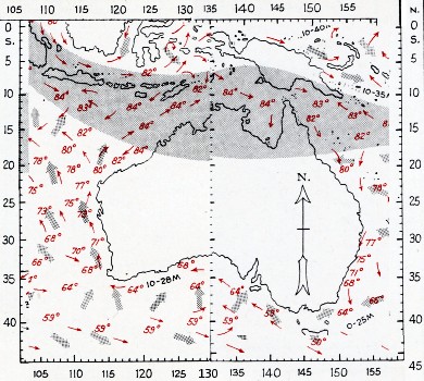
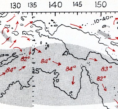
WINDS, OCEAN CURRENTS AND TEMPERATURES
To any raft or lifeboat in the open sea, the currents
and winds will be of greatest importance.
Because the movement of such craft is necessarily slow,
the effect on them of winds and currents will be
considerable.
For this reason, the accompanying wind and current
charts, plates 8 to 19, have been drawn so that the
effect of currents and winds may be taken into account.
These charts have been made for two opposite seasons of
the year so that the results for other months may be
judged proportionately between these two seasons.
The directions of the cold current streams of the oceans
are shown with black arrows; the warm cur¬rents are
shown in red. Where the daily rates of flow of currents
are known, they have been shown.
Sea temperatures are marked at various intervals and
from these can be determined the ocean stream in which
you find yourself.
It will be of great value to carry a small thermometer
as standard equipment in rafts or lifeboats.
The thermometer need have only a range from 340 to 85°
Fahrenheit.
The area contained by the Doldrums, which is a belt of
calms between the northeast and southeast Trade Winds,
is indicated by a gray band.
In the doldrums the wind will be found most variable,
the sky generally overcast, with frequent rain and wind
squalls.
The resultant winds in various parts of the oceans are
designated
Page 68
by large gray arrows.
An arrow does not mean that you will always get the wind
from that particular direction, but is the resultant
wind.
This resultant direction will be of more value than the
directions of what are usually termed prevailing winds.
The prevailing wind is the direction from which the wind
most often blows.
The resultant wind, as the name implies, is the result
of the prevailing and other winds which are ordinarily
found at that time and place. It is the effect over a
period of time and distance that will be of most value
to small craft.
Neither currents nor resultant winds should be
considered by themselves.
Your judgment must be made with consideration of both of
them; or if they are in opposite directions, which of
them will be to your greatest advantage.
It will depend upon your capacity to sail whether the
winds will have more effect than currents.
If you are in a strong current which is flowing in the
direction in which you desire to go, and the wind is
directly opposite, it may be of more advantage to put
out a sea anchor, thus holding yourself to the water,
than to be drifted in the other direction by the wind.
A sea anchor may consist of any object lowered below the
surface and which will act as a drag.
SYMBOLS ON CURRENT CHARTS
Gray band ... Doldrums Broad gray arrows
... Resultant winds Red arrows ...
Warm current streams Black arrows ...
Cold current streams Red figures in
italics ... Ocean temperatures,
warm streams Black figures in
italics ... Ocean temperatures,
cold streams Upright figures (as
10-30M) ... Drift of currents in miles
per day
Pages 78 and 80
Plate 16 Southwest Pacific and Plate18 Indian Ocean -
February, adjusted and detail [Torres Strait].
Page 93
...
HOW THE POLYNESIANS
USED THE STARS
Polynesians viewed the heavens as the inside of a shell or
pit which revolved around them.
The stars in this dome were seen to rise over the eastern
horizon and to descend and finally disappear over the
western horizon. Watching the heavens night after night they
saw that the stars stayed in the same relation to one
another; rotated around an imaginary axis, and that the same
stars month after month passed over the same islands.
They noted that although they kept this same path, they
appeared earlier each night (about four minutes with our way
of measuring time).
Page 94
In the course of a year, they observed that the stars had
the same position in the sky at the same time at night as
they had exactly a year before.
A complete rotation of this star sphere had taken place and
it was very clear to them that star time gained on sun time
by the amount of one day a year.
They viewed the stars as moving bands of light and knew all
the stars of each band which passed over the islands they
were interested in.
Their method of navigation by these heavenly beacons was to
sail towards the star which they knew was over their
destination at that particular time.
This was an amazingly simple system and required no
instruments.
To clarify this, let us imagine the stars stationary for a
moment.
Each star in the heavens will be exactly overhead at some
place on the surface of the earth.
If we know at this moment what star is over the island of
Hawaii, we have a shining beacon standing immediately above
the island and which can be seen thousands of miles away.
If we steer for this star, we actually follow the shortest
possible course which is called by navigators "a great
circle."
In modern navigation, due to the fact that a compass course
is not the shortest distance, an approximation has to be
made.
We then realize that the Polynesian system was more perfect
in principle than our modern methods.
Not only does this star give us the direction and the
shortest course to our island, but we are able to tell when
we are reaching it by getting right under the star.
This is all very simple while the heavens remain stationary.
Although primitive peoples had no mechanical means of
telling the time during the day or at night, they had a
perfect concept of time.
We think of distance in terms of miles and our whole habit
of thinking is one of space; whereas the Polynesian had no
word for distance, no use for space, but thought only of
time.
It was the time he took to get to a place that determined
how far away it was to him.
Page 95
The Tahitians divided the daytime into six divisions of time
and the same number during the night.
Without mechanical aids, it is not difficult for people to
judge accurately the passage of time, especially when their
habits are regular, as were the Polynesians', who ate at ten
in the morning, four in the afternoon, and retired at nine
o'clock at night.
The stomach is an excellent time keeper from its degree of
fullness or emptiness.
Once having established the definite and short period of
time that the stars rose earlier each night, they could then
be used as a reliable check on their time sense.
Now let us start the heavens moving again, and we are back
to the star that we are steering for, and which was over
Hawaii.
This star is now moving on a definite track westward.
Other stars which are the same distance north of the Equator
follow along exactly on that same track and the next star
which passes over Hawaii will be used to steer by.
In turn, this star will move on and the next star in the
same band will be used as a guide.
This process will continue until we arrive underneath the
star which, at that time of the year and at that time of the
night, will be directly over our destination.
It will be seen that, disregarding time entirely, we can
reach our destination by sailing along underneath this
narrow and circular band of stars which rotate year after
year over the island to which we are sailing.
Without taking time into account we can not make the
shortest course, but we will eventually get there if we know
whether we are east or west of our destination.
By following the Polynesian method, we are able without
instruments to arrive at any desired latitude closely enough
for our purpose.
I am not describing a precise system to supplant modern
navigation and instruments but a method which was
effectively used by the native navigators to bring them
within a reasonable distance of their island destinations.
Using only eye observations in this manner and
Page 96
getting within range of, say, 50 to 75 miles of the island,
they brought into use all the other natural means that we
have described earlier in the book for making the actual
landfall.
Not having had the opportunity to practice and thus become
as proficient as the Polynesians in the mental measurement
of time, if we want to sail as direct a course as they
could, we will have to make up for our lack of time concept
by the use of a watch.
The native navigators were walking almanacs in that they
remembered all the stars in those bands which passed over
the island to which they sailed.
Captain Cook was amazed at the ability of a native who
joined him at Tahiti and accompanied him as far as the East
Indies.
At any time during the passage, even as far as Batavia, when
asked in what direction Tahiti lay, he was able without
hesitation, night or day, to point very accurately in its
direction.
It is entirely impossible for any modern navigator to do the
same thing unless he does so by the Polynesian system of
"overhead or direction stars."
You will note that I said also during the day. He was able
to do this by knowing where the sun was overhead each day
and the relationship of its position with his home at any
time of year.
Should modern navigators not be impressed with the accuracy
possible by eye observations of overhead stars, it is well
to point out that the most modern ship afloat today goes
from dusk to dawn, even though the sky be filled with
glittering stars, without being able to determine its
position by those stars unless, on a rare occasion,
moonlight enables the horizon to be seen.
The Polynesians, on the other hand, were not tied to the
horizon, and made no use of it; they were not restricted as
we are and their system enabled them to use the stars all
night long.
The Polynesian method of overhead stars is particularly
suited for present day use in rafts or life boats.
As we have said before, the problems of the Polynesians were
identical with those of people in small craft on the high
seas.
No other method has been devised which is so practical for
ap-
Page 97
proximate navigation especially in tropical regions where
clear skies at night are the rule rather than the exception,
and where modern precision navigating instruments are either
lacking or unusable.
For this reason, we have brought the Polynesian methods back
to life, with certain improvements.
It has been recorded that
accomplished Polynesian navigators had names for 150 stars,
knew their positions, knew the position where they rose, and
the time they rose at different seasons of the year; knew
which islands they passed over and could direct their course
at sea by them from island to island.
This required long years of learning, which time we are not
prepared to spend in this way.
The native navigators were restricted to a knowledge of the
stars passing over islands with which they were familiar.
To obviate the necessity of remembering these positions, the
stars have been superimposed in red on the world chart, with
the stars in their proper positions relative to one another
and the earth, for a certain date and time.
To make up for our lack of time sense, a pocket watch should
be carried set to Greenwich time.
In this way, the Greenwich Date and Time Tape can be used to
find your position on the earth by means of the star which
is directly overhead at the time showing on your watch.
This is the only stellar method of navigation yet devised in
which the observer does not need to know the name of the
star he is using as long as he is able to recognize the star
on the Combined World and Star Chart.
Another advantage is that you do not need any instruments to
measure the height of the star above the horizon.
If you do not have a watch running on Greenwich time, you
are still able to obtain your latitude.
Included in this book are star diagrams to help you
recognize the general design of the principal constellations
or groups of stars so that you may pick out overhead stars
which are in their general vicinity.
Further details of these overhead stars and their movements
will
Page 98
be found in two subsequent chapters entitled, "How Far You
Are North or South" and "How Far You Are East or West."
In addition to the stars overhead at their destinations the
native navigators of the Pacific used "Steering Stars" which
method is discussed on page 117.
HOW TO RECOGNIZE
THE STARS
...
Page 117
STEERING BY THE
STARS
"If thou," he answered,
"follow but thy star,
Thou canst not miss at last a glorious haven."
DANTE
The native navigators in the Pacific were not limited to the
use of stars overhead of their destination.
It will be realized that, even though the heavens seem to be
filled with stars, there are occasions when no overhead star
is visible at the particular time that it is needed.
At such times, the Polynesians used a steering star which
was in line with their destination, either between their
position and the island or beyond it.
Imagining for a moment that the stars are held still, there
will be a considerable choice of stars in a direct line with
the place to which we are sailing.
These stars will be in a different band of latitude and will
not pass over the destination. However, for the moment, they
act as signposts in the heavens.
If the stars remained stationary, we could follow them
exactly as we do street lights.
Even though they are actually moving, if we pick one of
these stars to steer by and know its movement each hour, we
are able to keep a straight course by taking into account
this movement and by steering an increasing or decreasing
amount to one side of it, according to whether the star is
moving away from the destination or towards it.
We do not need to guess how much to steer to one side of it,
if we move our position in relation to the stars as
described in the last chapter.
By following this procedure we are able to measure the angle
at any time between the destination and the present position
of the star.
After the star moves to a point where it is no longer
practicable to steer a course relative to it, another star
may be chosen.
There will be a considerable choice of stars in line with
the destination, either on your side of it, beyond the
destination, or even behind you.
...
Page 120
... As long as the heavens are clear,
you can find your way anywhere on any ocean by following the
stars; thus giving a more literal meaning to Emerson's
advice, "Hitch your wagon to a star."
It is believed that this simple Polynesian method of chasing
stars, the knowledge of which has been buried for several
centuries, is a most practical one for the navigation of
rafts or lifeboats, and an adaptation of it might well be
used in up-to-date marine and air navigation.
The legends of the Polynesians are full of interesting
information regarding the direction stars used in sailing to
certain islands. One ancient Maori lament describes Rigel as
being the direction star which one navigator used sailing to
Rarotonga, and Castor as being a direction star for Hawaii.
Other accounts list the stars used during the long voyage of
the Maori fleet, which took place about 1350 A.D. from
Tahiti to New Zealand.
The biblical reference to the Star of Bethlehem would seem
to indicate a still earlier knowledge and use of "overhead"
or "direction" stars.
Page 125
HOW FAR ARE
YOU NORTH OR SOUTH
...
Page 128
LATITUDE BY THE
POLYNESIAN METHOD OF OVERHEAD STARS
The realization and application by the Polynesians of the
continued passage of the same stars over the same islands
year after year provide a simple means of obtaining latitude
at any time of the night without the necessity of having a
watch or any mechanical means of measuring height.
A watch is necessary for determining our position in an east
and west direction, but is not necessary for latitude.
In order to use the star chart it will be necessary to be
able to recognize the principal groups of stars or
constellations.
For this reason, star diagrams have been given covering the
main constellations.
If the sky is clear about you, look directly overhead and
pick the
Page 129
nearest star to your overhead point.
Find the next group of stars to it that you are able to
recognize from the star diagrams or the star chart.
Knowing a prominent constellation and seeing what direction
this particular star is from it, you will be able to tell
which one it is on the star chart.
Whether or not it is named on the star chart does not
matter. It will be easier to find on the chart if you will
look along a line at your approximate latitude.
The stars are superimposed in red on the world chart and to
use them for our method of position finding they appear on
the chart as viewed from above them.
In order to see them as they appear from an observer on the
surface, it will be necessary to turn to the back of the
world chart where the stars are in white on a black
background and are viewed as from below them.
After you have found the position of the overhead star on
the star chart, make sure that this star is actually
overhead.
You will find this quite easy in any small craft by
remaining stationary and picking out the star you think is
directly overhead and then either turning yourself or, what
will be much easier, paddling the raft or boat in circles.
You will usually be surprised when you turn 180 degrees and
find that the star you thought was overhead you will almost
break your neck to see.
The height of a star is invariably underestimated.
By turning yourself in this manner, you should actually be
able to determine the point directly overhead to half a
degree.
Even if the sea is rough, by taking longer over the
operation and judging it each time you think you are
temporarily level, your results will be reasonably close.
After you have found your overhead star and have recognized
it on the combined world and star chart, you know that this
is your latitude.
Remember that this means that you are on a line somewhere
around the world at this latitude, but that it does not in
anyway indicate your position in an east and west direction.
To
Page 130
find your position in an east and west direction, a
timepiece is needed running on Greenwich time.
This is explained in the chapter "How Far You Are East or
West." [pages 133-138, not reproduced]
The method of obtaining latitude by overhead stars can be
used on the darkest night when there is no horizon, and will
require neither instrument, watch, nor even the Harp.
One considerable advantage of the overhead star method is
that you do not have to identify the star by name as long as
you can recognize its position on the chart.
Should there be no star directly overhead at the time of
your observation, look for the star nearest to your overhead
point. Determine by methods previously explained, the north
and south, and east and west points of the horizon.
You are then able to judge whether the star will pass
overhead or not, or which stars may shortly become overhead
stars.
If you find that the star nearest your overhead point is
passing north or south of you, you may use hand measurements
to determine how many degrees north or south of your
overhead point it is passing.
If you find that a star is 50 directly south of the overhead
point, your latitude on the chart will be 50 farther north
than the latitude of the star.
LATITUDE BY THE
DURATION OF DAY
...
Page
139
MAKING THE
LANDING
Watching the state of the sea near possible harbors or bays
easy of access, little or no difficulty should be
experienced in making a landing.
In tropical waters, it will be useful to realize that where
the prevailing wind and the current are of the same
direction, atolls will almost invariably be shaped with
lagoon entrance on the side opposite the wind.
Because the coral polyps, whose skeletons form coral reefs
and islands, can only exist in water which is constantly
flowing over them, the islands assume different forms
according to the flow of the surface water.
As an illustration, in the northern part of the trade wind
belt, where the winds and currents are almost consistently
from the same direction throughout the year, an island
assumes a V shape with the
Page 140
apex directly into the prevailing wind and the wide base of
the V is on the lee side.
A perfect example of this is Kingman Reef about 1100 miles
south of Honolulu.
In regions where the prevailing winds may vary slightly, the
atoll assumes a somewhat oval shape with an entrance to the
lagoon on the side opposite the generally prevailing wind.
It is well to bear this in mind when approaching such an
island in order to make a landing. It will be usually
dangerous to attempt a landing on the windward side of an
island.
Even on the lee side of small solid islands, it will be
often found that there is an extremely heavy surf which is
hardly noticeable until it is too late to go back.
The writer had a sad experience at Baker Island in the
mid-Pacific in this way, where he was marooned for six days
because of capsizing in a short heavy surf.
With volcanic islands, such as American Samoa, where the
harbor of Pago Pago is formed from a crater, the entrance
will be on the windward side, for the reason that during the
time of eruption the scoria and lava blown by the wind made
the windward side of the crater much lower than the lee
side.
The action of the wind and sea in time has broken down the
low side of the crater and thus formed a deep water harbor.
Between Kingman Reef and Samoa, islands are encountered
along the Equator, such as Ocean Island, Nauru, Baker
Island, Jarvis Island, Maiden Island and Howland Island, all
of which have no lagoon and are built up on each side.
They are in a region which is subject to easterly winds at
one time of the year and westerly winds during the other.
When there is any doubt about the landing it will be wise to
remain outside breakers and try to signal the shore for help
from someone with local knowledge.
Gatty, Harold: The
Raft Book. Lore of the Sea and Sky George Grady, New York, 1943.